Documentation


Table of Contents
5 Mapas de red
Vista general
La exportación de mapas de red contiene:
- Todas las imágenes relacionadas
- Estructura del mapa - todos los ajustes del mapa, todos los elementos que contiene con sus ajustes, enlaces del mapa e indicadores de los enlaces del mapa
::: Notas de advertencia Todos los grupos de equipos, equipos, iniciadores, otros mapas u otros elementos que pudieran estar relacionados con el mapa exportado no son exportados. En consecuencia, si no está presente alguno de los elementos a los que el mapa hace referencia, la importación fallará. :::
La exportación/importación de mapas de red está soportada desde Zabbix 1.8.2.
Exportación
Para exportar mapas de red, haga lo siguiente:
- Vaya a : Monitorización → Mapas.
- Seleccione las casillas de los mapas de red a exportar.
- Pulse sobre Exportar debajo de la lista.
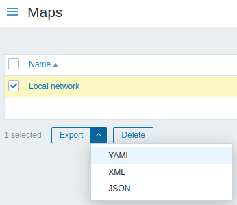
Dependiendo del formato seleccionado, los mapas son exportados en un fichero local con nombre por defecto:
- zabbix_export_maps.yaml - en la exportación YAML (opción por defecto)
- zabbix_export_maps.xml - en la exportación XML
- zabbix_export_maps.json - en la exportación JSON
Importación
Para importar mapas de red, haga lo siguiente:
- Vaya a: Monitorización → Mapas
- Pulse sobre Importar a la derecha.
- Seleccione el fichero a importar.
- Marque las opciones requeridas en las reglas de importación.
- Pulse en Importar.
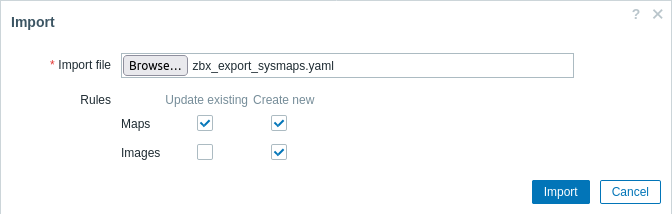
Reglas de importación:
| Regla | Descripción |
|---|---|
| Actualizar existentes | Los mapas existentes se actualizarán utilizando los datos del fichero de importación. Si no, no serán actualizados. |
| Crear nuevos | La importación añadirá nuevos mapas usando los datos del fichero de importación. Si no, no los añadirá. |
Si desmarca ambas opciones para el mapa y marca las respectivas opciones para las imágenes, solo serán importadas las imágenes. La importación de imágenes solo está disponible para usuarios Super Admin.
Si se reemplaza una imagen existente, afectará a todos los mapas que usan esta imagen.
Formato de exportación
Exportar a YAML:
zabbix_export:
         version: '6.4'
         images:
           - name: Zabbix_server_3D_(128)
             imagetype: '1'
             encodedImage: iVBOR...5CYII=
         maps:
           - name: 'Local network'
             width: '680'
             height: '200'
             label_type: '0'
             label_location: '0'
             highlight: '1'
             expandproblem: '1'
             markelements: '1'
             show_unack: '0'
             severity_min: '0'
             show_suppressed: '0'
             grid_size: '50'
             grid_show: '1'
             grid_align: '1'
             label_format: '0'
             label_type_host: '2'
             label_type_hostgroup: '2'
             label_type_trigger: '2'
             label_type_map: '2'
             label_type_image: '2'
             label_string_host: ''
             label_string_hostgroup: ''
             label_string_trigger: ''
             label_string_map: ''
             label_string_image: ''
             expand_macros: '1'
             background: {  }
             iconmap: {  }
             urls: {  }
             selements:
               - elementtype: '0'
                 elements:
                   - host: 'Zabbix server'
                 label: |
                   {HOST.NAME}
                   {HOST.CONN}
                 label_location: '0'
                 x: '111'
                 'y': '61'
                 elementsubtype: '0'
                 areatype: '0'
                 width: '200'
                 height: '200'
                 viewtype: '0'
                 use_iconmap: '0'
                 selementid: '1'
                 icon_off:
                   name: Zabbix_server_3D_(128)
                 icon_on: {  }
                 icon_disabled: {  }
                 icon_maintenance: {  }
                 urls: {  }
                 evaltype: '0'
             shapes:
               - type: '0'
                 x: '0'
                 'y': '0'
                 width: '680'
                 height: '15'
                 text: '{MAP.NAME}'
                 font: '9'
                 font_size: '11'
                 font_color: '000000'
                 text_halign: '0'
                 text_valign: '0'
                 border_type: '0'
                 border_width: '0'
                 border_color: '000000'
                 background_color: ''
                 zindex: '0'
             lines: {  }
             links: {  }
Etiquetas de elementos
Los valores de etiquetas de elemento se explican en la tabla de abajo.
| Elemento | Propiedad de elemento | Typo | Rango | Descripción |
|---|---|---|---|---|
| images | Elemento raíz para las imágenes. | |||
| name | string |
Nombre único de imagen. | ||
| imagetype | integer |
1 - imagen 2 - fondo |
Tipo de imagen. | |
| encodedImage | Imagen codificada en Base64. | |||
| maps | Elemento raíz para los mapas. | |||
| name | string |
Nombre único de mapa. | ||
| width | integer |
Anchura del mapa, en píxeles. | ||
| height | integer |
Altura del mapa, en píxeles. | ||
| label_type | integer |
0 - etiqueta 1 - dirección IP del equipo 2 - nombre de elemento 3 - solo estado 4 - nada |
Tipo de etiqueta de elemento de mapa. | |
| label_location | integer |
0 - abajo 1 - izquierda 2 - derecha 3 - arriba |
Localización por defecto de la etiqueta del elemento de mapa. | |
| highlight | integer |
0 - no 1 - sí |
Habilitar remarcado de icono para iniciadores activos y estados de equipo. | |
| expandproblem | integer |
0 - no 1 - Sí |
Mostrar iniciador del problema para elementos con un solo problema. | |
| markelements | integer |
0 - no 1 - Sí |
Remarcar los elementos del mapa que han cambiado su estado recientemente. | |
| show_unack | integer |
0 - Número de problemas 1 - número de problemas sin reconocer 2 - Número de problemas reconocidos y desconocidos de forma separada |
Visualización de problemas. | |
| severity_min | integer |
0 - no clasificado 1 - información 2 - alarma 3 - medio 4 - crítico 5 - desastre |
Severidad mínima del iniciador para mostrar por defecto en el mapa. | |
| show_suppressed | integer |
0 - no 1 - sí |
Mostrar problemas que estarían suprimidos (no serían mostrados) por mantenimiento del equipo. | |
| grid_size | integer |
20, 40, 50, 75 o 100 | Tamaño de celda de una cuadrícula de mapa en píxeles, si "grid_show=1" | |
| grid_show | integer |
0 - sí 1 - no |
Mostrar la cuadrícula en la configuración del mapa. | |
| grid_align | integer |
0 - sí 1 - no |
Alinear iconos automáticamente en la configuración del mapa. | |
| label_format | integer |
0 - no 1 - sí |
Utilizar configuración avanzada de etiquetas. | |
| label_type_host | integer |
0 - etiqueta 1 - dirección IP de equipo 2 - nombre de elemento 3 - solo estado 4 - nada 5 - etiqueta personalizada |
Visualización como etiqueta de equipo, si "label_format=1" | |
| label_type_hostgroup | integer |
0 - etiqueta 2 - nombre de elemento 3 - solo estado 4 - nada 5 - etiqueta personalizada |
Mostrar como etiqueta de grupo de equipo, si "label_format=1" | |
| label_type_trigger | integer |
0 - etiqueta 2 - nombre de elemento 3 - solo estado 4 - nada 5 - etiqueta personalizada |
Mostrar como etiqueta de iniciador, si "label_format=1" | |
| label_type_map | integer |
0 - etiqueta 2 - nombre de elemento 3 - solo estado 4 - nada 5 - etiqueta personalizada |
Mostrar como etiqueta de mapa, si "label_format=1" | |
| label_type_image | integer |
0 - etiqueta 2 - nombre de elemento 4 - nada 5 - etiqueta personalizada |
Mostrar como etiqueta de imagen, si "label_format=1" | |
| label_string_host | string |
Etiqueta personalizada para elementos de equipo, si "label_type_host=5" | ||
| label_string_hostgroup | string |
Etiqueta personalizada para elementos de grupo de equipos, si "label_type_hostgroup=5" | ||
| label_string_trigger | string |
Etiqueta personalizada para elementos de iniciadores, si "label_type_trigger=5" | ||
| label_string_map | string |
Etiqueta personalizada para elementos de mapa, si "label_type_map=5" | ||
| label_string_image | string |
Etiqueta personalizada para elementos de imagen, si "label_type_image=5" | ||
| expand_macros | integer |
0 - no 1 - sí |
Expandir macros en etiquetas en la configuración del mapa. | |
| background | id |
ID de la imagen de fondo (si existe), si "imagetype=2" | ||
| iconmap | id |
ID de la asignación de iconos (si corresponde). | ||
| urls | Utilizadas por los mapas o por cada elemento de mapa. | |||
| name | string |
Nombre de enlace. | ||
| url | string |
URL de enlace. | ||
| elementtype | integer |
0 - equipo 1 - mapa 2 - iniciador 3 - grupo de equipos 4 - imagen |
Tipo de elemento de mapa al que pertenece el enlace. | |
| selements | ||||
| elementtype | integer |
0 - equipo 1 - mapa 2 - iniciador 3 - grupo de equipos 4 - imagen |
Tipo de elemento de mapa. | |
| label | string |
Icon label. | ||
| label_location | integer |
-1 - usar la configuración por defecto del mapa 0 - abajo 1 - izquierda 2 - derecha 3 - arriba |
||
| x | integer |
Localización del eje X. | ||
| y | integer |
Localización del eje X. | ||
| elementsubtype | integer |
0 - grupo de equipos único 1 - todos los grupos de equipos |
Subtipo de elemento, si "elementtype=3" | |
| areatype | integer |
0 - igual que todo el mapa 1 - tamaño personalizado |
Tamaño del área, si "elementsubtype=1" | |
| width | integer |
Anchura del área, si "areatype=1" | ||
| height | integer |
Altura del área, si "areatype=1" | ||
| viewtype | integer |
0 - colocar uniformemente en el área | Algoritmo de ubicación del área, si "elementsubtype=1" | |
| use_iconmap | integer |
0 - no 1 - sí |
Usar asignación de icono para este elemento. Relevante solo si está activado el iconmapping a nivel de mapa. | |
| selementid | id |
Unique element record ID. | ||
| evaltype | integer |
Tipo de evaluación para etiquetas. | ||
| tags | Etiquetas de problema (para equipos y grupos de equipo). Si se proporcionan etiquetas, solo serán mostrados en el mapa los problemas con estas etiquetas. | |||
| tag | Nombre de etiqueta. | |||
| value | Valor de etiqueta. | |||
| operator | Operador. | |||
| elements | Entidades de Zabbix que son representadas en el mapa (equipo, grupo de equipo, mapa etc). | |||
| host | ||||
| icon_off | Imagen a utilizar cuando el elemento se encuentra en estado 'OK'. | |||
| icon_on | Imagen a utilizar cuando el elemento se encuentra en estado 'Problema'. | |||
| icon_disabled | Imagen a utilizar cuando el elemento está deshabilitado. | |||
| icon_maintenance | Imagen a utilizar cuando el elemento está en mantenimiento. | |||
| name | string |
Nombre único de imagen. | ||
| shapes | ||||
| type | integer |
0 - rectángulo 1 - elipse |
Tipo de forma. | |
| x | integer |
Coordenadas X de la forma en píxeles. | ||
| y | integer |
Coordenadas Y de la forma en píxeles. | ||
| width | integer |
Anchura de la forma. | ||
| height | integer |
Altura de la forma. | ||
| border_type | integer |
0 - ninguno 1 - línea gruesa 2 - línea punteada 3 - línea discontinua |
Tipo del borde de la forma. | |
| border_width | integer |
Anchura del borde en píxeles. | ||
| border_color | string |
Color del borde representado en código hexadecimal. | ||
| text | string |
Texto dentro de la forma. | ||
| font | integer |
0 - Georgia, serif 1 - "Palatino Linotype", "Book Antiqua", Palatino, serif 2 - "Times New Roman", Times, serif 3 - Arial, Helvetica, sans-serif 4 - "Arial Black", Gadget, sans-serif 5 - "Comic Sans MS", cursive, sans-serif 6 - Impact, Charcoal, sans-serif 7 - "Lucida Sans Unicode", "Lucida Grande", sans-serif 8 - Tahoma, Geneva, sans-serif 9 - "Trebuchet MS", Helvetica, sans-serif 10 - Verdana, Geneva, sans-serif 11 - "Courier New", Courier, monospace 12 - "Lucida Console", Monaco, monospace |
Estilo de fiente del texto. | |
| font_size | integer |
Tamaño de fuente en píxeles. | ||
| font_color | string |
Color de fuente representado en código hexadecimal. | ||
| text_halign | integer |
0 - centro 1 - izquierda 2 - derecha |
Alineación horizontal del texto. | |
| text_valign | integer |
0 - medio 1 - arriba 2 - abajo |
Alineación vertical del texto. | |
| background_color | string |
Color de fondo (relleno) representado en código hexadecimal. | ||
| zindex | integer |
Valor utilizado para ordenar todas las formas y líneas (z-index). | ||
| lines | ||||
| x1 | integer |
Coordenadas X del punto de línea 1 en píxeles. | ||
| y1 | integer |
Coordenadas Y del punto de línea 1 en píxeles. | ||
| x2 | integer |
Coordenadas X del punto de línea 2 en píxeles. | ||
| y2 | integer |
Coordenadas Y del punto de línea 1 en píxeles. | ||
| line_type | integer |
0 - ninguna 1 - línea gruesa 2 - línea punteada 3 - línea discontinua |
Tipo de línea. | |
| line_width | integer |
Anchura de línea en píxeles. | ||
| line_color | string |
Color de línea representado en código hexadecimal. | ||
| zindex | integer |
Valor utilizado para ordenar todas las formas y líneas (z-index). | ||
| links | Enlaces entre elementos del mapa. | |||
| drawtype | integer |
0 - línea 2 - línea gruesa 3 - línea punteada 4 - línea discontinua |
Estilo de línea. | |
| color | string |
Color de enlace (6 símbolos, hex). | ||
| label | string |
Etiqueta de enlace. | ||
| selementid1 | id |
ID del elemento a conectar. | ||
| selementid2 | id |
ID del otro elemento a conectar. | ||
| linktriggers | Indicadores de estado de enlace. | |||
| drawtype | integer |
0 - línea 2 - línea gruesa 3 - línea punteada 4 - línea discontinua |
Estilo de enlace cuando el iniciador se encuentra en el estado 'Problema'. | |
| color | string |
Color del enlace (6 símbolos, hex) cuando el iniciador se encuentra en estado 'Problema'. | ||
| trigger | Iniciador utilizado para indicar el estado del enlace. | |||
| description | string |
Nombre del iniciador. | ||
| expression | string |
Expresión del iniciador. | ||
| recovery_expression | string |
Expresión de recuperación del iniciador. |
Maps
| Element | Type | Description | |
|---|---|---|---|
| name | string | Unique map name. | |
| width | integer | Map width, in pixels. | |
| height | integer | Map height, in pixels. | |
| label_type | integer | Map element label type. Possible values: 0 - Label; 1 - Host IP address; 2 - Element name; 3 - Status only; 4 - Nothing. |
|
| label_location | integer | Map element label location by default. Possible values: 0 - Bottom; 1 - Left; 2 - Right; 3 - Top. |
|
| highlight | integer | Enable icon highlighting for active triggers and host statuses. Possible values: 0 - No; 1 - Yes. |
|
| expandproblem | integer | Display problem trigger for elements with a single problem. Possible values: 0 - No; 1 - Yes. |
|
| markelements | integer | Highlight map elements that have recently changed their status. Possible values: 0 - No; 1 - Yes. |
|
| show_unack | integer | Problem display. Possible values: 0 - Count of all problems; 1 - Count of unacknowledged problems; 2 - Count of acknowledged and unacknowledged problems separately. |
|
| severity_min | integer | Minimum trigger severity to show on the map by default. Possible values: 0 - Not classified; 1 - Information; 2 - Warning; 3 - Average; 4 - High; 5 - Disaster. |
|
| show_suppressed | integer | Display problems, which would otherwise be suppressed (not shown) because of host maintenance. Possible values: 0 - No; 1 - Yes. |
|
| grid_size | integer | Cell size of a map grid in pixels. Supported if grid_show is set to 0.Possible values: 20, 40, 50, 75 or 100. |
|
| grid_show | integer | Display a grid in map configuration. Possible values: 0 - Yes; 1 - No. |
|
| grid_align | integer | Automatically align icons in map configuration. Possible values: 0 - Yes; 1 - No. |
|
| label_format | integer | Use advanced label configuration. Possible values: 0 - No; 1 - Yes. |
|
| label_type_host | integer | Display label as host label. Supported if label_format is set to 1.Possible values: 0 - Label; 1 - Host IP address; 2 - Element name; 3 - Status only; 4 - Nothing; 5 - Custom label. |
|
| label_type_hostgroup | integer | Display label as host group label. Supported if label_format is set to 1.Possible values: 0 - Label; 2 - Element name; 3 - Status only; 4 - Nothing; 5 - Custom label. |
|
| label_type_trigger | integer | Display label as trigger label. Supported if label_format is set to 1.Possible values: 0 - Label; 2 - Element name; 3 - Status only; 4 - Nothing; 5 - Custom label. |
|
| label_type_map | integer | Display label as map label. Supported if label_format is set to 1.Possible values: 0 - Label; 2 - Element name; 3 - Status only; 4 - Nothing; 5 - Custom label. |
|
| label_type_image | integer | Display label as image label. Supported if label_format is set to 1.Possible values: 0 - Label; 2 - Element name; 4 - Nothing; 5 - Custom label. |
|
| label_string_host | string | Custom label for host elements. Supported if label_type_host is set to 5. |
|
| label_string_hostgroup | string | Custom label for host group elements. Supported if label_type_hostgroup is set to 5. |
|
| label_string_trigger | string | Custom label for trigger elements. Supported if label_type_trigger is set to 5. |
|
| label_string_map | string | Custom label for map elements. Supported if label_type_map is set to 5. |
|
| label_string_image | string | Custom label for image elements. Supported if label_type_image is set to 5. |
|
| expand_macros | integer | Expand macros in labels in map configuration. Possible values: 0 - No; 1 - Yes. |
|
| background | Root element for background image (if any). Supported if imagetype is set to 2. |
||
| name | string | Background image name. | |
| iconmap | Root element for icon mapping (if any). | ||
| name | string | Icon mapping name. | |
| urls | Root element for URLs used by maps or each map element. | ||
| name | string | Link name. | |
| url | string | Link URL. | |
| elementtype | integer | Map item type the link belongs to. Possible values: 0 - Host; 1 - Map; 2 - Trigger; 3 - Host group; 4 - Image. |
|
| selements | Root element for map selements. | ||
| shapes | Root element for map shapes. | ||
| type | integer | Shape type. Possible values: 0 - Rectangle; 1 - Ellipse. |
|
| x | integer | X coordinates of the shape in pixels. | |
| y | integer | Y coordinates of the shape in pixels. | |
| width | integer | Shape width. | |
| height | integer | Shape height. | |
| text | string | Text inside of shape. | |
| font | integer | Text font style. Possible values: 0 - Georgia, serif; 1 - "Palatino Linotype", "Book Antiqua", Palatino, serif; 2 - "Times New Roman", Times, serif; 3 - Arial, Helvetica, sans-serif; 4 - "Arial Black", Gadget, sans-serif; 5 - "Comic Sans MS", cursive, sans-serif; 6 - Impact, Charcoal, sans-serif; 7 - "Lucida Sans Unicode", "Lucida Grande", sans-serif; 8 - Tahoma, Geneva, sans-serif; 9 - "Trebuchet MS", Helvetica, sans-serif; 10 - Verdana, Geneva, sans-serif; 11 - "Courier New", Courier, monospace; 12 - "Lucida Console", Monaco, monospace. |
|
| font_size | integer | Font size in pixels. | |
| font_color | string | Font color represented in hexadecimal code. | |
| text_halign | integer | Horizontal alignment of text. Possible values: 0 - Center; 1 - Left; 2 - Right. |
|
| text_valign | integer | Vertical alignment of text. Possible values: 0 - Middle; 1 - Top; 2 - Bottom. |
|
| border_type | integer | Type of the border for the shape. Possible values: 0 - None; 1 - Bold line; 2 - Dotted line; 3 - Dashed line. |
|
| border_width | integer | Width of the border in pixels. | |
| border_color | string | Border color represented in hexadecimal code. | |
| background_color | string | Background (fill) color represented in hexadecimal code. | |
| zindex | integer | Value for ordering all shapes and lines (z-index). | |
| lines | Root element for map lines. | ||
| x1 | integer | X coordinates of the line point 1 in pixels. | |
| y1 | integer | Y coordinates of the line point 1 in pixels. | |
| x2 | integer | X coordinates of the line point 2 in pixels. | |
| y2 | integer | Y coordinates of the line point 2 in pixels. | |
| line_type | integer | Line type. Possible values: 0 - None; 1 - Bold line; 2 - Dotted line; 3 - Dashed line. |
|
| line_width | integer | Line width in pixels. | |
| line_color | string | Line color represented in hexadecimal code. | |
| zindex | integer | Value for ordering all shapes and lines (z-index). | |
| links | Root element for links between map elements. | ||
| drawtype | integer | Link style. Possible values: 0 - Line; 2 - Bold line; 3 - Dotted line; 4 - Dashed line. |
|
| color | string | Link color (6 symbols, hex). | |
| label | string | Link label. | |
| selementid1 | id | ID of one element to connect. | |
| selementid2 | id | ID of the other element to connect. | |
| linktriggers | Root element for link status indicators. | ||
See also: Map object (refer to the relevant property with a matching name).
Map selements
| Element | Type | Description | |
|---|---|---|---|
| elementtype | integer | Map element type. Possible values: 0 - Host; 1 - Map; 2 - Trigger; 3 - Host group; 4 - Image. |
|
| elements | Root element for Zabbix entities (host, host group, map, etc.) that are represented on the map. All entities have their respective element ( host, etc.; see, for example, Export format). |
||
| label | string | Icon label. | |
| label_location | integer | Label location. Possible values: -1 - Use map default; 0 - Bottom; 1 - Left; 2 - Right; 3 - Top. |
|
| x | integer | Location on the X axis. | |
| y | integer | Location on the Y axis. | |
| elementsubtype | integer | Element subtype. Supported if elementtype is set to 3.Possible values: 0 - Single host group; 1 - All host groups. |
|
| areatype | integer | Area size. Supported if elementtype is set to 1.Possible values: 0 - Same as whole map; 1 - Custom size. |
|
| width | integer | Width of area. Supported if areatype is set to 1. |
|
| height | integer | Height of area. Supported if areatype is set to 1. |
|
| viewtype | integer | Area placement algorithm. Supported if elementsubtype is set to 1.Possible values: 0 - Place evenly in the area. |
|
| use_iconmap | integer | Use icon mapping for this element. Relevant only if icon mapping is activated on map level. Possible values: 0 - No; 1 - Yes. |
|
| selementid | id | Unique element record ID. | |
| icon_off | Root element for image to use when element is in 'OK' status. | ||
| name | string | Unique image name. | |
| icon_on | Root element for image to use when element is in 'Problem' status. | ||
| name | string | Unique image name. | |
| icon_disabled | Root element for image to use when element is disabled. | ||
| name | string | Unique image name. | |
| icon_maintenance | Root element for image to use when element is in maintenance. | ||
| name | string | Unique image name. | |
| urls | Root element for URLs used by maps or each map element. | ||
| name | string | Link name. | |
| url | string | Link URL. | |
| evaltype | integer | Evaluation type for tags. | |
| tags | Root element for problem tags (for host and host group elements). If tags are given, only problems with these tags will be displayed on the map. |
||
| tag | string | Tag name. | |
| value | string | Tag value. | |
| operator | integer | Operator. | |
See also: Map element object (refer to the relevant property with a matching name).
Map link status indicators
| Element | Type | Description | |
|---|---|---|---|
| drawtype | integer | Link style when trigger is in the 'Problem' state. Possible values: 0 - Line; 2 - Bold line; 3 - Dotted line; 4 - Dashed line. |
|
| color | string | Link color (6 symbols, hex) when trigger is in the 'Problem' state. | |
| trigger | Root element for trigger used to indicate link status. | ||
| description | string | Trigger name. | |
| expression | string | Trigger expression. | |
| recovery_expression | string | Trigger recovery expression. | |
See also: Map link trigger object (refer to the relevant property with a matching name).